Rapid response
A unit overhead in minutes.
Somebody calls 911 about shots on your block. Right now the answer is however long it takes a car to get across town. With a launch point on this end of the island, there is an aircraft overhead in a couple of minutes, marking where it came from and holding live video until officers get there. The same aircraft can be over the ship channel and the cruise terminals just as fast. That is not a promise to solve crime. It is arrival time, and arrival time is the one thing we can improve without hiring a single person.
The City already flies one drone, from headquarters on 54th Street. It was paid for with a state grant to fight catalytic converter theft, and state law says that money is to be used only for that. So it is not the answer for every 911 call, or for the port. This page is about an aircraft of its own for the east end and the water, what it costs to keep flying, and the rules we should write down before we buy anything.
© 2026 Raymond Arce · Concept first published September 5, 2025 · Updated October 2, 2026
Twenty four seconds
The whole plan, quickly.
If you have less than a minute, watch this. It covers how fast air support should arrive, where the aircraft would launch from, and why this is not a camera on a pole.
Everything in it is on this page in writing, with the sources named.
What would make it a program
An idea is like a table.
Every table needs at least three legs to stand on. An aircraft is not a program. These three things have to be true at once, and each one pays for a weakness in the others.
Its own launch point
An upgraded five-mile aircraft docked at a secure location on the East End. From there it reaches downtown, the cruise terminals, UTMB, Stewart Beach, Fish Village, the ferry landing, Beachtown, the ship channel and Bolivar Roads.
If that site is not available, the same aircraft can work from a secure location on Pelican Island, right on the channel.
It is funded and flown for 911 calls and threats on the water, not borrowed from the catalytic converter program. The far west end is outside its reach, and I would rather say that here than have somebody find it later.
A funded second year
Grant money buys hardware. It does not buy pilots and their hours, batteries, docks, connectivity, software renewals, or the airframe we replace in year four. That bill lands on the general fund whether or not anybody planned for it.
This is where the County and the Port come in. From the County, we may only be asking for two things: help paying for it, and a secure home for the dock on the East End. The Port can apply for the federal port security grant, which pays for drones and drone detection. The Police Department flies it either way.
Rules in writing, first
Adopted before the new aircraft flies, not after somebody sues. Four commitments, spelled out further down this page, and every one of them checkable: what is allowed to launch a flight, how long footage is kept, who else is allowed to see it, and a public report anybody can read without filing a request for it.
Where it would fly from
Drawn to scale from parcel maps.
Same aircraft, two possible roofs. The red circle is a secure location on the East End. The yellow circle is the backup, a secure location on Pelican Island, in case the first site is not available. The gray dot is the drone the City already flies, shown for location only.
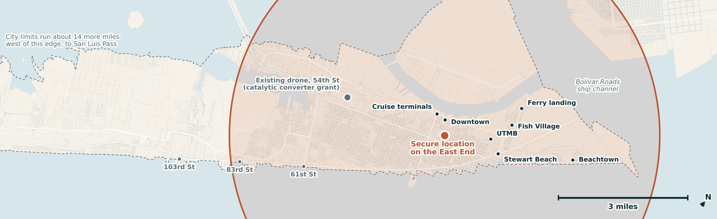
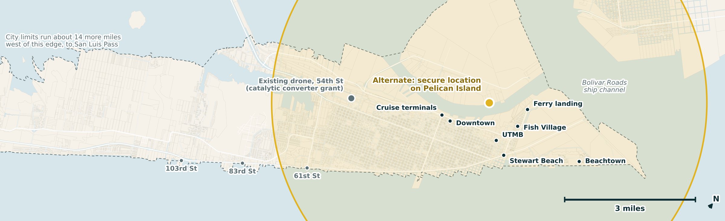
Galveston Central Appraisal District parcel, street and city limit data, April 14, 2026. The five-mile range is a figure to confirm with the vendor, the Department and the FAA. Either location needs the owner's agreement. Tap a map to open it full size.
Before you answer, be clear on what this is
This is not a camera on a pole.
Nothing here gets bolted to a pole. Nothing runs all day. Nothing sits and watches a street corner. An aircraft stays in its dock until a 911 call comes in, flies to that one address to help the officers already on their way, and comes back. That is the entire job.
What we are talking about
- Sits in a dock and does nothing until dispatched
- Goes up because somebody dialed 911
- Flies to that one address, assists, and comes home
- Every flight has a call behind it and can be published
This is not a scientific poll and I will not present it as one. It is a comment card. I read them.
In their words
Why neighbors want this.
From the comment cards on this page. A comment goes up here only when the person who wrote it says it can.
I was assaulted by a transient on 22nd Street and Sealy outside my home. I didn’t call police because I was aware the delay in response would eliminate any chance of finding him. The same person tried to attack my nephew a month later. Drone deployment would help significantly with situations like these.
The next one could be yours.
Leave a comment in the card above and check the box that says I can share it.
Where my numbers come from
Towns our size, with the receipts.
I would rather show you the arithmetic than ask you to take my word for it. Three cities already run this. Two of them are closer to Galveston's size than most people assume, and one of them shows how far a standard aircraft reaches.
Owasso, Oklahoma 43,117 residents. Galveston has about 53,000.
3 miles
How far one aircraft reaches
An Owasso officer states it on camera: about thirty to thirty five miles an hour, a three mile radius, anywhere in the city in under three minutes. That is a standard aircraft. This plan calls for an upgraded five mile model, so one roof can cover the whole east end and the water. News on 6 reports Owasso launches more than a dozen times a day.
Radius, speed and the under three minutes figure as reported by KJRH Channel 2 in Tulsa, launch frequency from News on 6. Population from the Census Bureau, July 2025.
Schenectady, New York 69,471 residents. The closest thing to a peer we have.
497 calls
What one launch point produces, and what one launch point costs
1,529 flights. The aircraft beat every patrol car to the scene in 868 of them, and 497 calls never needed a ground unit at all. That is the case for doing this. Here is the other half of it, and I am not going to leave it out: Schenectady pays $694,994 over six years for a single launch point, on a state grant its council approved in December 2023. Hardware is the cheap part. That is exactly why the second leg is a funded second year.
Flight counts from the National League of Cities. Contract amount, term and council date as reported by The Daily Gazette. Population from the Census Bureau, July 2025.
Chula Vista, California Five times our size. Cited here for one reason only.
Since 2018
Every flight, published where anyone can read it
Chula Vista flew the first program of this kind in the country on October 22, 2018. It is far bigger than Galveston, so nothing about its call volume proves anything about ours, and I am not going to pretend otherwise. What it proves is the third leg. The department puts its flight activity on a public dashboard that residents can open without filing a request for it. That is the part I want us to copy, and it is the part that costs nothing.
Program start date and the public flight dashboard from the Chula Vista Police Department.
None of these cities is Galveston, and none of these numbers is a promise about what would happen here. I am putting them on this page because a plan that only works when you take the candidate's word for it is not a plan. If you find a figure here that does not hold up, write me and I will correct it on this page.
The part I care most about
The state's report, filed by choice.
Texas Government Code Section 423.008 has police post a public report on their drone flights every two years: where and when each one flew, why it launched, what it helped with, what it recorded of people who were not involved, and what it cost. Senate Bill 2569 moved that report onto the agency's website in 2025.
It applies only to police in cities and counties over 150,000 people. Galveston has about 53,000, so for our Police Department it is optional. I think we should file it anyway. It costs nothing, the statute already says what goes in it, and it is the honest answer to anyone worried about where this goes next.
One more thing, so nobody oversells it. State law does not make a city our size write its own drone rules either. Section 423.007 leaves those to the Department of Public Safety. The four rules below are my proposal, not something the state already requires.
What we would put in writing
Response, not surveillance.
Here is the difference that matters, and it is worth saying plainly. A camera on a pole watches a place. It is always on, nobody called it, and it collects everyone who walks past. This does the opposite. It goes up because somebody called, it flies to that one address, and it comes home. It does not patrol, it does not circle a neighborhood, and it is not up there looking for something to find. Four commitments, in writing.
Launch on a call, not on a hunch
The aircraft goes up because a call came in. No patrol patterns, no orbiting, no flights looking for something to find.
A retention clock, published
Footage that is not evidence gets deleted on a stated schedule, and the schedule is ours rather than a vendor's default setting.
Say who else can see it
Name every agency and every vendor the data touches. The Police Department flies it, so that list starts with one department, even with the County and the Port at the table. The city attorney raised data sharing on the camera contracts in 2023 and it has not gotten less important since.
Publish a tracker, not just a report
Every flight, why it launched, what it cost, on a public dashboard anyone can open. Not filed somewhere and forgotten. Other cities already do this and it is the next block on this page.
The camera debate left a lot of people in this city uneasy, and they were right to ask hard questions. This is a different tool and it should be held to a different standard. But a promise about how a tool will be used is not a policy. That is why this gets adopted before the new aircraft flies, and not after somebody has to sue to find out what the rules were.
The part I would go furthest on
You should be able to watch the flight log.
Two cities already let anyone do this without filing a request, and I would copy both.
Lewisville, Texas runs a drone first responder program with a public dashboard that updates on a short delay while flights are happening. You can see that an aircraft is up and roughly where it went. The map pins are deliberately randomized so the dashboard never publishes the address of the person who called 911. Their page also carries the policy itself and the complaint procedure.
Chula Vista publishes every flight afterward: date, time, case number, block address, the call type, and the flight path drawn on a map, going back years. Open it right now and you can read what their aircraft did this morning.
That is what I want here, and it costs almost nothing. The vendors already collect this data.
Now the part I am not going to promise, because somebody will ask. Not the live video. In June 2026 security researchers found five San Francisco Police drone feeds, color and thermal, sitting on the open internet behind a sharing link with no password, along with thousands of GPS coordinates and the pilots' names. They had been reachable for six months. Nobody broke in. Somebody just made a link. Live public video of a police aircraft means broadcasting a stranger's worst afternoon, and it is one configuration mistake away from something worse. The flight log is the part the public actually needs, and it is the part that can be published safely.
What the FAA has to approve
Flying low is not the same as flying legal.
The first question people ask is whether the drone can just stay under 400 feet. It cannot get around the federal rules that way. Here is what the FAA actually looks at, and why the paperwork has to start now.
Height is not sight
A drone has to stay under 400 feet and in its pilot's sight. Those are two separate rules. A flight that goes miles out to a 911 call breaks the sight rule at any height, so the Department needs FAA permission first.
Low is how the permission works
The FAA's public safety waiver lets police fly beyond sight at or below 200 feet, staying close to buildings and trees. Flying up to 400 feet takes approved equipment that detects other aircraft.
The airport's airspace
Scholes airport's controlled airspace reaches 4.1 miles out while the tower is open, 6 a.m. to 6 p.m. It covers about 60 percent of the property the new aircraft would reach, from about 31st Street west. Flights there need FAA airspace approval.
Crowds and darkness
Flying over crowds at the cruise terminals or Stewart Beach takes an approved aircraft type, prop guards or a parachute, except to save a life. Night flights are allowed with the right lighting and training.
Rules: 14 CFR 107.29, 107.31, 107.39, 107.41 and 107.51, and the FAA's public safety toolkit. Airspace: the Galveston Class D description published in the Federal Register on December 9, 2005, and the tower's posted hours. The airspace share is my own calculation from appraisal district parcel data. A new FAA rule for these flights, Part 108, is in final review, and it may change some of this when it publishes.
We live on an island
There are only so many ways off it.
That is a strategic advantage and we are not using it. Nothing here asks for a purchase, a contract or a budget amendment. It asks for four things. Seek an interlocal agreement among the City, the County and the Port. Ask whether the County would help pay for it and help find a secure home for the dock on the East End. Price the five-mile aircraft and what it costs to keep flying through year six. And adopt written flight rules and the state's public flight report, by choice.